
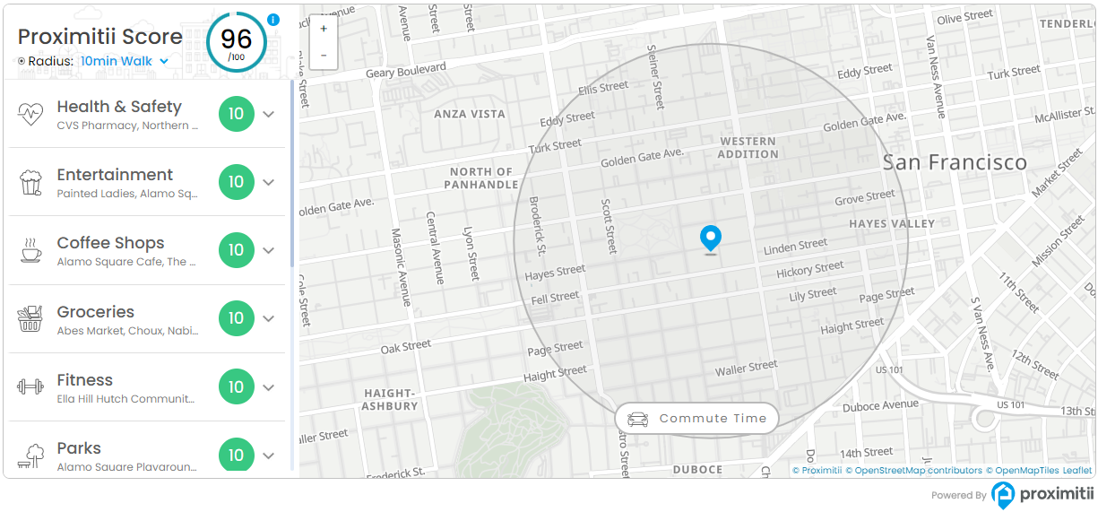
The Local Lifestyle Widget displays a neighborhood score, nearby points of interest, category scores, highlights, commute tools, and optional report download controls for a specific latitude and longitude.
Installation
Add the following embed code to your page or template. Replace the widget key and coordinates with your own values.
<div id="prox-local-lifestyle"></div>

<script src="https://widget.proximitii.com/v1/core/proximitii-widget.js?v=33"></script>

<script>
ProximitiiWidgets.localLifestyle({
  container: 'prox-local-lifestyle',
  widgetKey: "PUT_YOUR_WIDGET_KEY_HERE",
  lat: 43.66068291135164,
  lon: -79.34739798021833
});
</script>
Always provide a valid widgetKey, lat, and lon. All other settings are optional and fall back to the defaults listed below.
Customization
The following Local Lifestyle Widget customization options are available.
General Options:
| Name | Description | Default Value | Accepted Values | Variable / Function |
|---|---|---|---|---|
| Container | The ID of the div where the widget renders. | N/A | Any valid element ID | container |
| Widget Key | Your public widget key. | N/A | Valid Proximitii widget key | widgetKey |
| Latitude | Sets the latitude of the center location. | N/A | Decimal between -90 and 90 | lat |
| Longitude | Sets the longitude of the center location. | N/A | Decimal between -180 and 180 | lon |
| Language | Sets the widget language. | en | en or fr | language |
| Layout | Controls the primary desktop layout. | bottom | bottom or left | layout |
| Box Style | Controls the widget container styling. | shadow | shadow or flat | boxStyle |
| Widget Height | Sets the widget height. | 610px | CSS size | widgetHeight |
| Default Zoom Level | Sets the starting map zoom. | 15 | Number from 12 to 20 | defaultZoomLevel |
| Max POIs Per Category | Limits the number of POIs shown for each category. | 16 | Number from 5 to 25 | maxPoisPerCategory |
Content Options:
| Name | Description | Default Value | Accepted Values | Variable / Function |
|---|---|---|---|---|
| Score Title | Sets the title shown with the overall score. | Proximitii Score | Any valid text | scoreTitle |
| Score Title Font Size | Sets the score title font size. | 30px | CSS size | scoreTitleFontSize |
| Show Top Header | Shows or hides the top header area. | true | true/false | showTopHeader |
| Show Proximitii Score | Shows or hides the overall Proximitii score. | true | true/false | showProximitiiScore |
| Show Customize | Shows or hides the customize control. | true | true/false | showCustomize |
| Show Highlights | Shows or hides the highlights section. | true | true/false | showHighlights |
| Show Download Report | Shows or hides the download report button. | true | true/false | showDownloadReport |
| Show Bottom Footer/Left Panel | Shows or hides the bottom category footer or left layout panel. | true | true/false | showBottomFooter |
| Show Main Category Scores | Shows or hides main category scores. | true | true/false | showMainCategoryScores |
| Show Sub Category Scores | Shows or hides subcategory scores. | true | true/false | showSubCategoryScores |
| Show Commute Button | Shows or hides the commute button. | true | true/false | showCommuteButton |
| Show Walking Distance Radius | Shows or hides the walking distance radius. | true | true/false | showWalkingDistanceRadius |
Appearance Options:
| Name | Description | Default Value | Accepted Values | Variable / Function |
|---|---|---|---|---|
| Show Border | Shows or hides the widget border. | true | true/false | showBorder |
| Primary Color | Sets the primary brand color. | #607eb8 | Hex color | primaryColor |
| Secondary Color | Sets the secondary panel/background color. | #EEF2F6 | Hex color | secondaryColor |
| Font Family | Sets the widget font family. | Poppins, sans-serif | Any valid CSS font-family | fontFamily |
| Disable Gesture Handling | Disables scroll-wheel and gesture handling on the map. | false | true/false | disableGestureHandling |
Map Options:
| Name | Description | Default Value | Accepted Values | Variable / Function |
|---|---|---|---|---|
| Map Provider | Selects the map provider. | proximitii | proximitii, google, mapbox, maptiler | mapProvider |
| Proximitii Map Style | Sets the Proximitii map style. | light | light, bright, modern, baseline | mapStyle |
| Google Maps API Key | Sets the Google Maps key when using Google Maps. | N/A | Valid Google Maps API key | googleMapsKey |
| Google Map Style | Sets the Google map type. | roadmap | roadmap, satellite, hybrid, terrain | googleMapType |
| Mapbox Public Token | Sets the Mapbox public token when using Mapbox. | N/A | Valid Mapbox public token | mapboxToken |
| Mapbox Map Style | Sets the Mapbox style. | mapbox/streets-v12 | streets, outdoors, light, dark, satellite | mapboxStyle |
| MapTiler API Key | Sets the MapTiler key when using MapTiler. | N/A | Valid MapTiler API key | maptilerKey |
| MapTiler Map Style | Sets the MapTiler style. | streets-v4 | streets-v4 and supported MapTiler styles | maptilerStyle |
Categories
Use categories to control main category order and visibility, and subcategories to control the POI categories shown in the widget.
| Category Type | Category Name | Variable | Individual Toggle |
|---|---|---|---|
| Main | Walkability | walkability | categoryWalkability |
| Main | Education | education | categoryEducation |
| Main | Active Living | active-living | categoryActiveLiving |
| Main | Transit Access | transit-access | categoryTransitAccess |
| Sub | Child Care | childcare | categoryChildcare |
| Sub | Coffee Shops | coffee | categoryCoffee |
| Sub | Elementary Schools | elem | categoryElementary |
| Sub | Entertainment | entertainment | categoryEntertainment |
| Sub | Fitness Facilities | fitness | categoryFitness |
| Sub | Food & Drink | food | categoryFood |
| Sub | Groceries | grocery | categoryGroceries |
| Sub | Health & Safety | health | categoryHealth |
| Sub | High Schools | high | categoryHighSchools |
| Sub | Parks | park | categoryParks |
| Sub | Shops | shop | categoryShops |
| Sub | Transit Stops/Stations | transit | categoryTransit |